Fears over “illustrative map” showing Gatwick flight path over Copthorne and Crawley Down
Copthorne and Crawley Down residents have expressed disbelief that a map released by the Airports Commission about Gatwick’s proposed 2nd runway shows what appears to be plans for a new flightpath directly over their homes. The Airports Commission insisted on the production of a map showing a flight path to assess the “operational viability” of the runway, but Gatwick management and NATS say it should “not be interpreted as representative of the location of future flight paths” The map is from a NATS document, which says “These designs are for illustrative purposes only and should not be interpreted as representative of the location of future flight paths, should a particular scheme be recommended….” Although there is currently no permanent flight path in place over the area, residents from both Copthorne and Crawley Down have complained of noise from changes to flight paths over the past year, including the introduction of a “concentrated flight path. People have become eer more aware of the planes and increasingly concerned about future increases, with planes using a new southern runway 1km south of the current one creating yet more noise near them.
.
Tweet
Fears over “illustrative map” showing Gatwick flight path over Copthorne and Crawley Down
17.1.2015 (East Grinstead Courier)
By Jo Gilbert
COPTHORNE and Crawley Down residents have expressed disbelief that a map released by the Airports Commission relating to Gatwick’s proposed second runway shows what appears to be plans for a new flightpath directly over their homes.
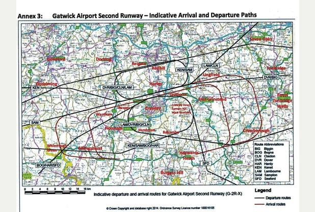
Map is from Annexe 3: Gatwick Airport Second Runway – indicative Arrival and Departure Paths
Page 39 of https://www.gov.uk/government/uploads/system/uploads/attachment_data/file/371854/14-operational-efficiency–airspace.pdf
“NATS Support to the Airports Commission” (not dated)
The Airports Commission – appointed by the Government to recommend at which airport an additional runway should be built – insisted on the production of a map showing a flight path to assess the “operational viability” of a second runway at Gatwick, but airport management say it should “not be interpreted as representative of the location of future flight paths” and that it is for illustrative purposes only.
The map was produced by the Airports Commission using information supplied by Gatwick’s management.
Although there is currently no permanent flight path in place over the Worth area, residents from both Copthorne and Crawley Down have complained of noise from changes to flight paths over the past year, including the introduction of “concentrated” paths where flights are flown in a tight air corridor.
Eddie Lord, a former British Airways pilot and resident of Borers Arms Road, Copthorne, said: “I think the activity coming from Gatwick this year has made everyone sensitive to the possibility of more noise. The concentrated flight paths have made it worse for people in certain areas, but even if it turns out that the flight path won’t be coming over Copthorne or Crawley Down, a second runway 1km south of the current one will mean the noise is 1km closer. There’s no doubt the noise will have a huge impact on everyone living in the area.”
A spokesman for Gatwick Airport said: “As the document makes clear, these maps are for illustration purposes only so it is incorrect and misleading to suggest they show the future flight paths of a second runway.
“Any new flight paths will be subject to detailed study and would be required to be designed in a way that avoids over-flying communities and minimises the number of people affected. These illustrative lines do not reflect that policy and so should not be taken to represent a proposal.”
But Sally Pavey, secretary of the Gatwick Area Conservation Campaign (GACC), believes that trial flight paths and concentrated flight paths over Copthorne and Crawley Down is evidence that future plans to introduce permanent flight paths over Worth are already under way.
She said: “This has caused many residents misery in the Worth area as they suffer a constant flow of planes above their homes. These concentrated routes continue even now. The flight paths have to go somewhere and the map showing ‘indicative flight paths” over Worth are very suspicious. Residents will get hammered by noise.”
Concerned Worth resident Jane Wilson added: “There are many people living in the area who do not realise the scale of what is being proposed. I think the most important thing is that people are informed and that they respond to the Airports Commission consultation.”
All material relating to the consultation can be found at http://tinyurl.com/m53v8j2
.
The document (presumably by NATS, though it unprofessionally gives neither date nor author), linked above, states:
“For the purposes of assessing the operational viability of each scheme proposal it was
necessary to produce indicative flight path designs. These designs are for illustrative
purposes only and should not be interpreted as representative of the location of future
flight paths, should a particular scheme be recommended and ultimately granted
Government approval. It should also be noted that finalising the routes of future flight
paths will be a matter for detailed design in future years prior to runway opening.
• For the Gatwick Airport Second Runway proposal, indicative flight path designs were
constructed by the Commission in conjunction with expert advisers – please see Annex 3.”