Flight paths of Heathrow 3rd runway travel over, and parallel to, M4. Safety and distraction issue?
The planned north-west runway at Heathrow, that the UK government is very keen to push through, runs close to the M4 motorway. This is a very busy stretch of road, with much of the traffic associated with Heathrow, in one way or another. The arrival flight path from the east, onto the 3rd runway, would run over parts of it, and very close to other parts, for some distance close to the airport. This is where the planes are at their lowest and most noisy. Currently along the boundary roads of the airport there are barriers, to prevent drivers seeing the planes – at ground level – and being distracted. However, with planes flying low overhead or parallel to the road for some distance, no barriers would be able to obscure the view.possible. It is not clear whether any consideration has been given by the DfT to the problem of driver distraction (or even driver nervousness) to have planes quite so low, flying parallel and in view. There are around 130,000 vehicles per day on that stretch of the M4 – meaning over 6,000 per hour – it is a very busy section of road, and due to become yet busier with a new runway. No other major airport has busy motorway with approximately the same alignment as the flight path – there is something comparable for one Tokyo runway. Will the government take into account the safety problems of this motorway / flight path clash?
.
Tweet
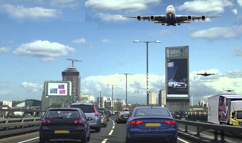
The overall length of an A380 is about 238 feet (72 metres) and the wingspan is about 260 feet (79 metres). When one of these planes is 500 feet overhead, that is merely two widths of a plane – which gives an indication of just how huge the plane would look to a person below.
While regular users of the M4 may become used to the distraction of giant planes moving fast, with extreme noise, above them, would drivers who use the road infrequently be as able to ignore them?
Is there a real safety issue here?
.
Arrivals from the east (on westerlies)
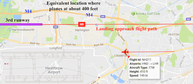
Indicative map showing approach path, from the east (airport on westerlies) towards the 3rd runway. Note where the M4 is, and the distance where it would be directly under the arriving planes. The red box is approximately where planes would be at 400 feet altitude, with a screenshot of one plane the equivalent distance from the northern runway, from Heathrow Webtrak)
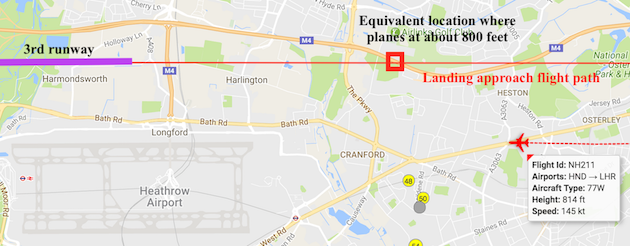
Indicative map showing approach path, from the east (airport on westerlies) towards the 3rd runway. Note where the M4 is, and the distance where it would be directly under the arriving planes. The red box is approximately where planes would be at 800 feet altitude, with a screenshot of one plane the equivalent distance from the northern runway, from Heathrow Webtrak)
.
Arrivals from the west (on easterlies)
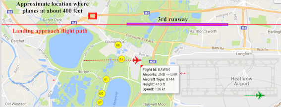
Indicative map showing approach path, from the west (airport on easterlies) towards the 3rd runway. Note where the M4 is. The red box is approximately where planes would be at 400 feet altitude, with a screenshot of one plane the equivalent distance from the northern runway, from Heathrow Webtrak). Note how close the flight path is from the M4 when planes are at around 400 feet, and how the flight path crosses the M4 with planes at around 500 feet.
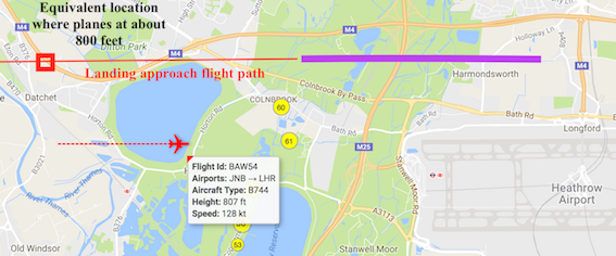 Indicative map showing approach path, from the west (airport on easterlies) towards the 3rd runway. Note where the M4 is. The red box is approximately where planes would be at 800 feet altitude, with a screenshot of one plane the equivalent distance from the northern runway, from Heathrow Webtrak). Note how the flight path crosses the M4 twice – at heights of around 800 feet the first time, and around 500 feet the second time – as well as running parallel with it for many miles.
.
Details of the numbers of vehicles using the M4 are from the DfT
https://www.dft.gov.uk/traffic-counts/cp.php?la=Hillingdon
Around 150 – 160,000 vehicles per day on the section of the M4 that would be under the flight path to the west of Heathrow. See section 16012 data at http://api.dft.gov.uk/v2/trafficcounts/countpoint/id/16012.csv
https://www.dft.gov.uk/traffic-counts/cp.php?la=Hillingdon#16012
Around 130,000 vehicles per day on the section of the M4 that would be under the flight path. See section 6013 data at http://api.dft.gov.uk/v2/trafficcounts/countpoint/id/6013.csv
https://www.dft.gov.uk/traffic-counts/cp.php?la=Hillingdon#6013
Do other major airports in the world have flight paths over long stretches of busy motorway?
In a word, No. Except one at Tokyo, Haneda.
Below are links to the world’s busiest airports (a 2 runway Heathrow ranks around 6th globally) by passenger numbers.
Chicago O’Hare airport
https://www.google.co.uk/maps/place/O’Hare+International+Airport+(ORD)/@41.9744512,-87.9831139,11.69z/data=!4m5!3m4!1s0x0:0x511747070259ad4b!8m2!3d41.9741625!4d-87.9073214
Tokyo Haneda airport
https://www.google.co.uk/maps/place/Haneda+Airport+(HND)/@35.5712186,139.7594748,161m/data=!3m1!1e3!4m5!3m4!1s0x0:0xd32c3a9d146f8df!8m2!3d35.5493932!4d139.7798386 (There is one flight path close to a motorway)
Los Angeles airport
https://www.google.co.uk/maps/place/Los+Angeles+International+Airport/@33.9296711,-118.4221043,13.13z/data=!4m5!3m4!1s0x0:0x77a87b57698badf1!8m2!3d33.9415889!4d-118.40853
Paris Charles de Gaulle
https://www.google.co.uk/maps/place/Charles+de+Gaulle+Airport+(CDG)/@49.0089407,2.4491755,11.83z/data=!4m5!3m4!1s0x0:0x42be0982f5ba62c!8m2!3d49.0096906!4d2.5479245
Dallas Fort Worth airport
https://www.google.co.uk/maps/place/DFW+International+Airport/@32.8765112,-97.0539128,13.47z/data=!4m5!3m4!1s0x0:0x73323f5e067d201c!8m2!3d32.8998091!4d-97.0403352
and
.
Artist’s impression of how the M4 might look, with an A380 some 500 feet overhead
.
.
.
.