Revised Public Safety Zone at Leeds Bradford airport – public consultation
In the UK there are 31 airports with Public Safety Zones. These are triagular shaped areas at the ends of runways, which show the areas where the risk of an aircraft crash is significant, and the risk contours. The area of a PSZ corresponds to the 1 in 100,000 individual risk contour, with additional lower risk contours. The CAA is now in charge of these PSZs, and reviews them every 7 years to take into account anticipated changes in air traffic over the next 15 years. The PSZ gets larger if there are more planes flown. There is a general presumption against new development within PSZs due to the safety risk, though existing activities are allowed to continue within a PSZ. The PSZ for Leeds Bradford is now being reviewed and was out for public consultation until 4th April 2013. In the new revised PSZ 60 properties have been included in the new proposed PSZ area and a further 32 houses have been removed. The PSZ areas each end of the runway now cover a slightly larger area. Some residents have been shocked to find they are in the PSZ without being aware of it.
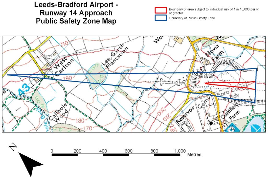
CAA document giving some information about the “proposal to Revise the Public Safety Zones at Leeds Bradford Airport ” including a map to show the PSZ area at
http://www.caa.co.uk/docs/2399/20130221LeedsBradfordAirportPSZNotificationDocument.pdf
There is also “Leeds Bradford Airport Public Safety Zones – Frequently Asked Questions” at http://www.caa.co.uk/docs/2399/20130221LeedsBradfordAirportPSZFAQs.pdf which contains a lot of simple information (questions and answers) about what PSZs are.
These include:
Q: What is the basic policy objective in establishing the PSZs?
A: The objective is that there should be no increase in the number of people living, working or congregating in PSZs and that, over time, the number should be reduced as circumstances allow (e.g. when any redevelopment takes place).
.and
Q:What is the level of risk associated with a PSZ?
A: The area of a PSZ corresponds to the 1 in 100,000 individual risk contour for that airport. What this means is that any person who lives within this risk contour for a period of a year, or has their normal place of work within this contour, has approximately a 1 in 100,000 chance per year of being killed as a result of an aircraft accident. Compared to other risks we take every day, this is very low.
.and
Q: How does this risk compare to other risks in daily life?
A: The 1 in 100,000 individual risk associated with a PSZ is actually a low level of risk compared with many other risks that most people encounter in their daily lives. For example, the risk of being killed in a road accident is about 1 in 18,500 – equating to 2,946 deaths.2 The risk of being killed in the home is higher still, the Royal Society for the Prevention of Accidents (RoSPA) estimates that there are approximately 4,000 deaths as a result of an accident in the home.

Larger version of the map at link (page 4)
By contrast, the maps of the two previous PSZs are below (slightly longer than the new one)

House price fears over Leeds Bradford Airport ‘danger zone’
 Sixty properties around Leeds Bradford Airport are included in a new Public Safety Zone.
By Laura Bowyer (Yorkshire Evening Post)
6th April 2013
Residents fear house prices will suffer after they discovered they were earmarked as living in a danger zone near the airport.
The Yorkshire Evening Post can reveal 60 properties around Leeds Bradford Airport have been included in a new Public Safety Zone (PSZ).
The zone, which has been drawn up by the Civil Aviation Authority, identifies space at the end of runways that could be at risk in the event of an aircraft accident.
They also carry certain planning restrictions and aim to control the number of people on the ground who are at risk if a plane crashes on take-off or landing.
Christine Bull, who has lived in her Horsforth home since 1997, was shocked to discover her home was included in a PSZ that was drawn up in 2002.
She was only made aware following a recent consultation about altering the zones, which ended earlier this week.
Her bungalow on Arran Drive has now been excluded from the new zone. She said: “We found it absolutely devastating. We had never been aware. All this time we have had no consultation. We were in a zone and they say you’re not now.”
She claims 12 homes on her estate have been included in the PSZ and there are fears it could impact house prices.
She added: “This will now have a major impact on the resale value of the properties and also any future building plans for the 12 properties.”
A spokesman from the Civil Aviation Authority said they started overseeing PSZ in 2010 and before that the Department of Transport was responsible for them.
He confirmed that 60 properties have been included in the new proposed area and a further 32 houses have been removed from the public safety zone.
.
.
Recent passenger numbers at Leeds Bradford over the past 10 years can be see at CAA airport data 2002 – 2012
.
.
General information about airport Public Safety Zones
The Department for Transport is revising the existing contours to take account
of updated traffic forecasts and aircraft mix at the airport 15 years ahead, to make
sure that the contours are as robust as possible. It is Government policy that PSZs should be updated approximately every seven years to ensure that the data underpinning the contours are reliable. It has not been prompted by any new proposals or plans at the Airport.. Currently 31 out of the 129 licensed airports in the UK have PSZs.
This update of the PSZs is standard DfT policy. Overall, the size and shape of
each PSZ will change very little. The risk to those living, working or congregating in
PSZs is still very low
The area of a PSZ corresponds to the 1 in 100,000 individual risk contour for that airport. What this means is that any person who lives within this risk contour for a period of a year, or has their normal place of work within this contour, has approximately a 1 in 100,000 chance per year of being killed as a result of an aircraft accident. Compared to other risks we take every day, this is very low.
When will the new PSZs take effect?
A: The contours have been issued in draft form to allow for a 6-week notification
period before they are finalised and put in place. However, given that this policy
relates to public safety, we would expect the Local Planning Authorities to take the
draft contours into account with immediate effect on receiving any planning
applications within the affected area.
In cases where there are residential, commercial or industrial properties within the higher risk contour (1 in 10,000 PSZ contour shown in blue in the maps within the notification document), close to the end of a runway, we would expect the airport operator to offer to buy and empty those properties. However, our current information is that there are no such properties in this case, either in the current or proposed new PSZ.
If you are aware of any inhabited properties in the inner contour, please let us know.
Public Safety Zones are produced by modelling work carried out using historic aircraft accident data from around the world, together with details of the traffic forecasts and particular aircraft mix at the Airport, to determine the level of risk to people on the ground. This modelling work determines the extent of the Public Safety Zone contours.
Within PSZs, establishment of all but the lowest occupancy land uses is to be discouraged and, over time, reduced. There is no requirement to remove existing development except from “inner” PSZs closer to the airport where the risk of a crash is much higher.
The PSZs correspond approximately to the areas where the annual risk of death to an
individual present constantly exceeds 1 in 100,000. The model of individual risk used to
define PSZs was developed by a team led by National Air Traffic Services (NATS) in the
1990s and has been updated by NATS since. The DfT finances the model development
and the production of PSZs but only the original model has been published. Although
AEF understands that the model is peer-reviewed, we believe that the model should be
in the public domain for reasons set out later.