Heathrow runway would mean loss of at least 431 hectares of Green Belt – and more in future
Date added: 6 October, 2015
The CPRE (Campaign to Protect Rural England) believes the Airports Commission’s terms of reference were flawed, and therefore so is its recommendation of a Heathrow runway. Looking at the Heathrow north west runway option, CPRE say it would destroy up to 694 hectares of Green Belt (one AC report says 694, another says 431 hectares). It would destroy 60 hectares of woodland. The runway would also wreck tranquillity in parks and gardens with impacts likely to spread into the Chilterns AONB. It would mean destroying 783 homes, and require up to 70,800 new homes to be built by 2030. In addition, the Commission said in November 2014: “The land take associated with the additional housing demand may require some de-designation of areas of the Green Belt, although the London Plan’s encouragement of high density housing and brownfield redevelopment may reduce this.” More houses may need to be built after 2030, and this would be in an area that already has acute housing pressure. CPRE considered that the formation of the Airports Commission, and its terms of reference, prevented a more ambitious regional rebalancing strategy. Instead the UK needs to boost the northern regions, avoid further over-heating the South East and make the most of the ample spare capacity in other airports.
.
Third Heathrow runway would be full frontal assault on Green Belt and tranquillity
1 July 2015 (CPRE – Campaign to Protect Rural England)
Airports Commission’s flawed terms of reference meant its recommendation of a destructive new runway was inevitable, say rural campaigners
The Campaign to Protect Rural England (CPRE) condemned today’s decision of the Airports Commission to recommend a third runway at Heathrow [1].
If it is ever built, the proposed Heathrow north western runway would be expected to [2]:
Ralph Smyth, transport campaign manager at the Campaign to Protect Rural England (CPRE), comments:
“The recommendation today for a third runway at Heathrow casts a dark shadow over a wide swathe of the south east. Besides the destruction of much of the ancient village of Harmondsworth to make way for the new runway, a much wider area is at threat. On top of the almost relentless din of jet engines, runaway development and traffic would shatter the remaining fragments of tranquil countryside in the south east, already one of the most densely overflown areas in the world.
“All of the options short-listed by the Airports Commission would have a devastating impact on the countryside, directly as well as indirectly. But, equally, they would undermine the national imperative of rebalancing our economy away from the overheated south east. London already has 50% more flights to it than any other city in the world and enough’s enough. We believe that the growing political consensus over the need for a Northern Powerhouse will effectively pull the rug from under the Commission’s report . We now need a national spatial plan to rebalance growth and aviation, making the most of the ample spare capacity in other airports.
“While the Airports Commission in some ways set new standards for public engagement, it was clear that its terms of reference were rigged from the start. Another new runway in the south east was the foregone conclusion, preventing proper consideration of greater use of high speed rail or an ambitious regional rebalancing strategy.”
ENDS
Notes to Editors
[1] You can download the Airports Commission report and CPRE’s most recent response to the Commission
[2] Figures from Airports Commission’s final report. 1.7.2015
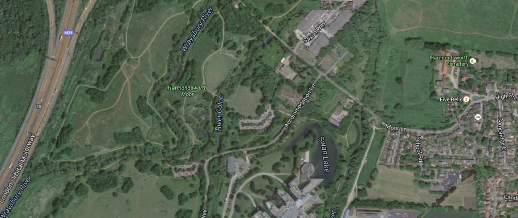
Harmondsworth Moor.
The north west runway would mean the destruction of Harmondsworth Moor. The Moor consists of 260 acres of reclaimed land near Heathrow Airport, it contains meadows, rivers, lakes and ponds and has 70,000 newly planted trees and several miles of new paths and bridleways. The park is managed by British Airways.
Details of Walks on the Moor.
Map showing Harmondsworth Moor (area to the east of the M25)
The Airports Commission’s Final Report states:
Page 100
“5.13 In total, 569ha of land would be directly required for the airport development, with up to an additional 43ha for flood storage and 294ha for related surface access improvements. Approximately 431ha of this is within designated Green Belt. These land take requirements however, could change following detailed construction and surface access route design, and any potential mitigations.”
and on Page 102 (for the Heathrow Hub extended northern runway option):
“5.18 The airport’s footprint would expand to the west, north and south, with a total direct land take of 336ha. Additional land take for surface access improvements and flood storage of up to 330ha and 57ha respectively may also be required. Approximately 278ha of the proposed land take would lie within Green Belt. As for the other schemes, these land take requirements could change following detailed construction and surface access route design, and any potential mitigations.”
The Airports Commission’s Business Case and Sustainability Appraisal (Nov 2014) for the Heathrow runway states:
“1.56 The additional employment supported by Heathrow’s expansion would lead to a significant requirement for additional housing. The Commission’s analysis indicates this would total between 29,800 and 70,800 houses by 2030 within the local authorities assessed as part of the local economy assessment. This additional housing and population growth would also require substantial supporting infrastructure including schools and health care facilities.
“1.57 Delivering new housing of this scale will present challenges for local authorities, many of whom already struggle to meet housing targets. This is mitigated to some degree however by the timescales for delivery and the broad area (some 14 authorities) over which the requirement is spread. Labour market flexibility and strong surface access links may enable this area to be extended further. The land take associated with the additional housing demand may require some de-designation of areas of the Green Belt, although the London Plan’s encouragement of high density housing and brownfield redevelopment may reduce this.”
.
Strategic fit
18. England is unique within Europe, if not developed countries anywhere, in not
having any national spatial plan. The lack of such a plan means that there has been no
assessment of the suitability of further airport expansion in the south east with the
political consensus that the regions in England need to be rebalance. So, for example, the
assessment of strategic fit of expanding Heathrow is only able to state that each
expansion proposal ‘has the potential to align well with local and regional development
strategies’.
19. The fact that this would put even more pressure on the Green Belt and ecosystem
services such as water, besides depriving the midlands and the north of beneficial
economic growth that could be accommodated largely within previously developed sites,
is at best ignored. At worst, environmental limits are actively encouraged to be breached.
Paragraph 2.84 states, for example that ‘the land take associated with additional housing
demand resulting from airport expansion could be challenging for individual authorities
and potentially require de-designation of areas of Green Belt. Each borough council’s plan
contains a theme of greenfield land preservation; an intention synonymous with that of
the development of town centres for housing purposes. While most local authority plans
have shied away from Green Belt development, this strategy may need to be considered
given the potential housing pressures and limited alternatives.’
20. The scale of what is proposed is such that this is a matter of utmost importance
and concern. As the consultation document notes, an expanded Heathrow would be the
‘biggest in the world alongside new Istanbul airport’, while an expanded Gatwick would be
as big as Heathrow is currently. As its site is bounded on three sides by nationally
designated landscape, this would be entirely unsuitable.
.
26. Finally we are very concerned that the indirect impact on the Green Belt has not
been adequately considered. Although the direct impact has been assessed (e,g, for the
North Western Runway at Heathrow this would be as much as 431ha), the indirect affects
have not been. These include pressure for additional housing and employment
development required due to local economic activity catalysed by airport expansion and
similarly to provide for additional transport infrastructure. In any event the impacts on
the Green Belt, if not designated landscapes, of widening of existing transport
infrastructure such as the M25, do not appear to have been assessed in any detail.
CPRE’s response to the Commission
.
The Campaign to Protect Rural England (CPRE) fights for a better future for the English countryside. We work locally and nationally to protect, shape and enhance a beautiful, thriving countryside for everyone to value and enjoy. Our members are united in their love for England’s landscapes and rural communities, and stand up for the countryside, so it can continue to sustain, enchant and inspire future generations. Founded in 1926, President: Sir Andrew Motion, Patron: Her Majesty The Queen.
Posted: Tuesday, October 6th, 2015. Filed in General News, News about Airports, Recent News.