For up-to-date information on the campaigns it represents please visit:
No Airport Expansion! is a campaign group that aims to provide a rallying point for the many local groups campaigning against airport expansion projects throughout the UK.
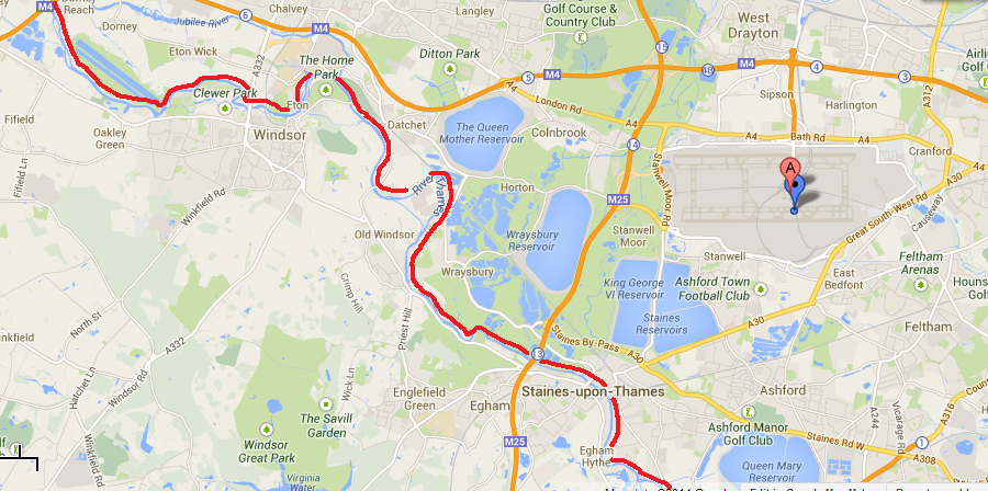
Fears in Heathrow area that a 3rd runway with associated infrastructure could add to local flood risk
Date added: 11 February, 2014
The western end of Heathrow is within 3 miles of the River Thames. The western end of the airport is within 3 – 4 miles of Datchet, Old Windsor and Wraysbury, as well as Staines. These areas are currently experiencing unprecedented flooding, due to some of the wettest weather and more continuous storms and rainfall for several hundred years (which is consistent with predictions of climate change from rising global CO2 emissions). Heathrow airport itself covers a huge area in impermeable surfaces, and its storm drainage is on a vast scale. There were already fears from previous years of its impact on the drainage of the area. It has the River Colne running along its western edge, and the River Crane along its eastern edge. A report in 2003 for Hacan recommended that a full EIA should be carried out on the impact of a 3rd runway on the Heathrow flood plain; and that as expansion of Heathrow would have a significant impact on water levels in an area much wider than just the Heathrow flood plain a detailed analysis is carried out in the impact a 3rd runway would have on rivers across a wider area. In addition that no decision should be made on a 3rd runway until full analysis has been done and has been put out to wide public consultation. . Tweet
Red line shows course of River Thames
Map showinglocation of River Colne, along the western edge of Heathrow, and the River Crane along the east of the airport
UK flood victims on alert as fears of looting and yet more water intensify
Residents whose homes and businesses are hit by rising Thames voice anger that help has come largely from volunteers
As darkness fell, residents of flooded areas in Berkshire just a couple of miles from Heathrow formed community groups to watch over their homes in the absence of the police.
“We’ve seen a few suspicious looking vans without number plates just prowling around in the last couple of days,” said Richard Levett, standing in knee-high water as planes roared over the suburban bungalows and two-storey homes around Brookside Avenue, part of an estate a mile north of the centre of Wraysbury.
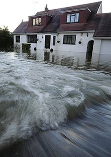
Floodwaters rush into a home in Wraysbury. (Andy Rain/EPA)
“And they want to build the new runway here?” he added, pointing to a two-storey house that he said had sold for £1.1m some months ago, but which now had small brown waves lapping at the front door.
Next door, an elderly couple were packing their belongings into a car as they headed off to spend the night in a hotel, locking up their flooded bungalow behind them. “It’s just crazy. People have been warning BAA [Heathrow’s operators] that this area was at risk of flooding like this.”
In common with other locals gathered at corners of the estate, there was frustration both at the media and at the authorities for not paying attention to flooding in the area, which was said to have started at least two days ago.
Residents said a police helicopter had flown over the area earlier in the day and asked, via loudspeaker, if anyone wanted to be evacuated. By the early evening however, there was no sign of anything like the yellow-vested groups of officials to be seen elsewhere in and around Staines and Wraysbury, an area where many homes had barely dried out since the last flooding in the area.
Among the volunteers was John Burrows, who lives in the Brookside estate with his wife and two daughters, one of whom has limited mobility. “The water was up to the top step of our house by early evening and we’ve been told to expect another foot tonight, so it seems like it’s going to come into our house,” said Burrows, who was making his way from his house through near waist-high water in his waders.
“We moved in here in 2004 but we really never expected that it could be like this. We’re going to stay tonight and see what happens, although we’re going to be moving as many things as possible up to upper floors of the house.
“The one thing about it all is that the local sense of community has really come through. People have been looking out for each other, knocking on doors and organising themselves into groups for this evening. To be honest, there could have been more support from the authorities. There could have been more sandbags distributed for example.”
Minutes later, a van arrived carrying a fibre-glass bottomed boat. Behind the wheel was Leo Hibbett, who had made the journey from Ashford, Surrey, to bring supplies – and a pair of wellies – for his 73-year-old mother who was stranded in her house at the top of the estate.
“I’m bringing some things down to her and I’ll probably try to also rescue the fridge freezer, which is in her garage, but she is happy to stay there for now anyway,” said Hibbett, who was helped by local residents to haul the boat down from the van before he took to the oars and rowed away.
As the waters continued to rise last night, groups of residents waited to help others who decided that they may want to leave their homes, while some turned their thoughts to how they would get to work today with cars trapped inside driveways and some stations along the rail line to Londonclosed.
Looking back on recent days, many pointed the finger at the distribution of flood defences which they said had prioritised some areas at the expense of areas such as Wraysbury and Datchet, another village which was also hard hit by the floods but where the army and emergency services had been working since Sunday.
In Datchet, Tracey Green, 43, said: “If we get more rain tonight and tomorrow I think it’s going to be quite rough. We’re already prepared at home. We’ve moved stuff upstairs. It’s bad, really bad.”
“I hope they’ve got some sort of SOS plan in mind. There’s a lot of elderly people in this village. I think it could be potentially quite bad. Somerset and what’s going on there at the moment is evidence of that. (I’m) dreading it to be honest.”
Interesting report done for HACAN in 2003 about drainage from Heathrow airport, and implications for flooding from a 3rd runway with all associated infrastructure.
The Department for Transport admits building a 3rd runway at Heathrow will cause a major problem with flooding on the surrounding flood plain. But only devotes two paragraphs of a 170 page report to it. HACAN ClearSkies delves beneath the surface……
One section of the report is copied below:
Part 1: Lack of Government Research
The Department for Transport admits in SERAS that a 3rd runway could cause flooding problems:
“Both options, maximum use of the existing runway and a new runway option, present potential High Adverse impacts on surface water and groundwater. There are numerous areas of contami nation around the airport that are at risk of being mobilised within all the development options. Although this could be controlled through appropriate management, there is a high risk to the aquifer which is an important resource. All of the options require engineering works, diverting or culverting, to at least one river. The Environment Agency is generally opposed to culverting and such works are seen as a significant impact.” (para 7.23)
“The extra passengers associ ated with an additional runway add to the demand for water which may be difficult to meet, even with supply and demand management and water saving technology” (para 7.24) The Department for Transport says nothing more about the flooding problem if a 3rd runway is built at Heathrow. There is no evidence to suggest:
– it has done any detailed work;
– it has asked the Environment Agency to look the situation. The Environment Agency confirm that no ground water modelling has been carried out by them to assess the impact on the flood plain of the proposed third runway. The Department claim modelling w ill be done after Government approval.
– it has made any attempt to see what solutions may be available;
– it has used PPG 25 (Planning Policy Guidance 25), which issues guidance for building on flood plains, to assess the impact of a 3rd runway on this flood plain.
—-
And the report concludes:
Part 7: Recommendations
Flooding has been a significant problem for areas in and around the Heathrow flood plain in recent years. According to scientific experts, severe floods will occur more often in coming decades. Therefore, it would appear that the Department for Transport has been irresponsible in not assessing the impact of a 3rd runway on the flood plain before the publication of the Aviation White Paper. This report, therefore, recommends:
– that a full Environmental Assessment is carried out on the impact of a 3rd runway on the Heathrow flood plain.
It is clear that 3rd runway could have a significant impact on water levels in an area much wider than just the Heathrow flood plain. This report, therefore, recommends:
– that a detailed analysis is carried out in the impact a 3rd runway would have on rivers across a wider area. And, finally, this report recommends:
-that no decision is made on a 3rd runway until the above work has been done and has been put out to wide public consultation.
.
Outskirts of London now flooding – HEATHROW AIRPORT only 24 feet higher than flood water
February 10th, 2014
The Thames is now flooding Egham & another town,Staines which is west of central London. Staines is just 2.5 miles from Heathrow airport. Elevation of Staines 18m. Elevation of Heathrow: 26m.24 foot difference.
The River Crane and Duke of Northumberland’s River form part of West London Green Chain, a twenty mile chain of interconnected green spaces that runs along the River Crane and its key tributary, the Yeading Brook, to the River Thames. It is recognised as a vital wildlife corridor, allowing the movement of birds and small mammals and the distribution of plant species through the urban landscape of west London. If you are not exactly sure where this area is then look at Streetmap.
Friends Of the River Crane Environment (FORCE) was formed in the summer of 2003 to represent the interests of local residents regarding the River Crane and Duke of Northumberland’s River and their respective corridors within the London Borough of Richmond upon Thames and its environs, and to provide sustainable improvements to these environments for the benefit of local people and visitors, the flora and fauna.
.
.
Earlier:
Thames Water’s dilemma: flood Heathrow or a river with sewage?
When the company was forced to choose between economic infrastructure and the natural world, the ecosystem lost
3.11.2011 (Guardian)
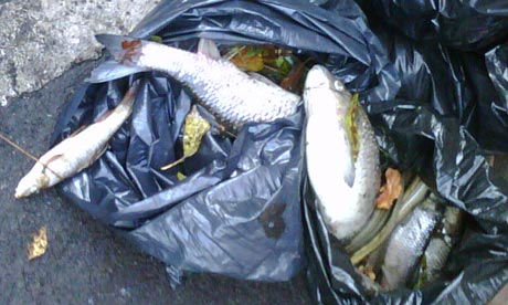
River life along a seven-mile stretch of a tributary of the River Thames has been wiped out after a major pollution incident. An estimated 3,000 fish have been killed so far. Photograph: UK Environment Agency
Imagine the scene: tens of thousands of tonnes of sewage have backed up behind a jammed gate and a decision has to be made – to flood one of the world’s busiest airports or inundate a small river very few people know exist.
It is a stark version of the choices made daily around the planet between costly economic infrastructure and the natural world: inevitably, the River Crane, and its populations of perch, eels, kingfishers and dragonfly larvae, lost.
The Environment Agency, the UK’s official enforcement body, now reports almost the entire west London river has been “killed” by the huge influx of grey sludge washed down the toilets and drains of nearby Heathrow airport, starting last Saturday night. Experts, who estimate 3,000 fish are floating dead in and along the oxygen-starved Thames tributary, say it will take “months, probably years” to recover. Anglers and other people are being warned to stay out of the water in the seven mile stretch from the A4 to the River Thames at Twickenham, though the risk to the Thames itself is thought to be low.
Thames Water issued an apology in which the company said engineers battled for hours to free the jammed sluice gate and commandeered 20 trucks to haul sewage away by road before being:
“Faced with the unpalatable choice of letting the remaining sewage back up into the airport or spill to the River Crane, we were forced to opt for the latter.”
The company also stressed that rather than wait for a prosecution, it had volunteered to work with the Environment Agency on an immediate clean-up.
There will be many who support Thames Water’s decision: the closure of such a crucial piece of infrastructure would have caused chaos, for passengers around the world, and taken days to sort out. Others will feel that the ecology of a whole river, in an already built-up area, is more important than some temporary (and smelly) inconvenience to passengers. The Crane might not have the romance of a wild salmon stream or the majesty of one of the great rivers of the world, but in a heavily urbanised and industrial area it will be, literally, a lifeline for far more than fish: for plants, insects and birds and small mamals to live in and travel through, and a valuable green space for local people.
In this case, too, the comparison of choices is also made harder by conflicting stories about the scale of likely consequences. Thames told me its modelling showed that, had it not released the sewage into the Crane, it would have washed down into the road tunnel entering Heathrow, forcing the owners, BAA, to close the airport on Sunday afternoon, as thousands of people returned from half-term holidays. It could also have affected the airport’s fire brigade, said the company.
However a spokeswoman for Heathrow told me:
“There was a possible risk to terminals one and three but there were contingency plans in place to avoid disruption to passengers.”
Those plans included trucking in temporary loo blocks and trucking out the sewage. The EA said it was told after the sewage was released into the river.
Weighing on Thames Water’s corporate mind might also have been the likelihood of enormous negative publicity and millions of pounds of possible compensation claims from BAA, airlines, hotels and other local businesses.
In the event, almost nobody but local groups noticed the Crane dying, and the cost of a clean-up is more likely to be in the tens of thousands. Fish don’t sue.
Later Richard Aylard, the company’s director of external affairs and sustainability, contacted the Guardian to explain that the original statement might have been misleading. “There wasn’t a situation where there was a man with a lever in front of him saying ‘one way: flood Heathrow; the other way: flood the river’,” said Aylard. Instead, said Aylard, engineers had to decide whether to block the built-in sewage overflow into the Crane, without knowing where the raw sewage might end up if they did. “They took what they thought was the right decision at the time, which was not to over-ride a built in safety mechanism,” he added.
There is far more awareness of the value of nature’s “ecosystem services”, especially after the publication last year of a global assessment commissioned by the UN, and this year in the UK theNational Ecosystem Assessment and the attendent Natural Environment White Paper. All have generated a lot of interest in monetising nature, and some hope that within a few years planned decisions – in this case whether to make a river teeming with wildlife the default emergency sewage drain – will take better account of those values.
Creating an environment in which more immediate decisions are made which at least give the environment a fair chance against more obvious economic interests is harder to do, though, admits Ian Bateman, professor of environmental economics at the University of East Anglia.
“The big one will be when you make it in the interest of private companies to make profits out of the environment: then they’ll have an interest in the environmental quality,” he suggests.
Allowing companies to make profits from protecting the natural world will be very controversial with many of its most vocal protectors. But it needs to be considered if we are to reach a point where a sewage company would consider flooding a road before a river.
Airports use a large amount of water and create a significant amount of rainfall runoff which must be managed appropriately before it leaves the airport. This is required to avoid harm to local watercourses and flooding.
As Heathrow’s owner, we work to reduce the amount of water needed for airport activities and to supply water from more sustainable sources where possible.
Managing water
Use and source water in a sustainable way
Reducing demand for water by using water efficient technologies in all new buildings and during refurbishment of older facilities, investigating and repairing leaks and raising awareness of the importance of water efficiency.
Using non-potable water where feasible for sanitation, irrigation and other activities instead of using treated mains drinking water.
Control pollution hazards at source
Minimising pollution risks and encouraging airport third party companies to minimise any impacts from their activities.
Wherever possible, contain the contamination from winter de-icing activity (airport and aircraft) including recovering used aircraft de-icing fluid where practicable.
Respond immediately to incidents and contain any harmful substances as close to the source as possible.
Protect and enhance local water courses
Control the flow and quality of water entering local watercourses through extensive pollution control infrastructure. This includes reservoirs and balancing ponds to store runoff and advanced biological treatment facilities.
Investment planned during 2014-2019 to further improve the airport’s pollution control infrastructure.
Regular monitoring of local water courses to assess the health of the aquatic environment
.Comment from a resident in Harmondsworth about recent flooding.
11.2.2014
“We are seeing the consequences of river diversions for airport terminals. I was told a couple of weeks ago that gates on the river had been closed to keep, I thought T4 dry, and the result was flooding in Accommodation Lane/Saxon Way, flooding the allotments and impacting on the property over the bridge in Moor Lane and the other farm near the bollards in Accommodation Lane. The River Colne, Saxon Lake, and footpaths have become one and are impassable from Harmondsworth Moor. No access to West Drayton unless you have a canoe or plan to swim! ”
“A 3rd runway WILL be built on the floodplain…..They messed around with the local rivers for Terminal 5 and now look what’s happening.”
.
14 January 2014 (BBC)
Wraysbury residents say Jubilee River is a ‘disaster’
Old Windsor residents say it has caused more homes to flood since it opened
Work by the Environment Agency to control flood water on the Thames has been a “disaster” for Wraysbury, according to residents.
The £110m Jubilee River opened in 2002, and was planned to reduce flooding in Maidenhead, Windsor, Eton and Cookham.
Wraysbury and Old Windsor residents say it has caused more homes to flood since it opened.
The agency said the scheme was working as planned and it may extend the river to protect more flood-prone areas.
In flood conditions the Jubilee River diverts water from the River Thames upstream of Maidenhead
This reduces flood levels in the River Thames running through Maidenhead, Windsor, Eton and Cookham
The Jubilee River rejoins the Thames downstream of Windsor, and does not provide protection to communities downstream of the scheme
The Environment Agency states the Jubilee River does not adversely affect flood levels downstream
The Jubilee River has been running at full capacity since 7 January
This is the first time the Jubilee River has run at full capacity since it was opened in 2002
‘Sacrificial lambs’
Graham Sinclair, who lives in Wraysbury, said his neighbours were “very angry”.
“It’s grossly unfair that a man-made river can be to the benefit of some people and to the detriment of others,” he said.
Flood warden Gillie Bolton who lives on Ham Island in Old Windsor, said: “I believe we are being used as sacrificial lambs to stop Maidenhead from flooding.”
However, the Environment Agency says the Jubilee River has worked well to protect Maidenhead and Eton.
The Environment Agency’s Barry Russell said a review had been held following similar floods in 2003, which found the Jubilee River was operating as planned.
He said the agency planned to extend the scheme to protect Wraysbury and Old Windsor in the future, but this would cost £256m.
“We have very extensive plans to continue the Jubilee River all the way down from Datchet down to Teddington.
“It’s very expensive but it’s got huge support,” he said.